Participant Information
Check-In
The UltraChallenge will take place rain or shine. All participants must check in at the Brookville YMCA between 4 AM and 5:30 AM on Saturday, August 23 where you will receive your race packet and ID tag. You may also check in on Friday evening between 6 PM and 8 PM. Please pin the tag on your right side at waist level so it can be scanned at each Checkpoint. You are responsible for ensuring your tag is properly scanned!
Starting
The shuttle bus will depart from the YMCA at 5:25 AM to take the individual participants and first leg relay team members to the trailhead where their tags will be scanned as they start out, as early as 6:05 AM if there is sufficient light. All participants must take the shuttle bus; there is no parking at the trailhead.
Aid Stations and Checkpoints
There are 11 aid stations along the course providing water, sport drinks, gels, sandwiches, and bananas. Candy such as M&Ms; and other snacks will be available at some stations. Four of these stations are also relay transfer spots and checkpoints where your tag will be scanned and your time recorded. Except for the start, relay teams are responsible for their own transportation to and from each transfer spot. Each Checkpoint has a designated cutoff time; participants must depart the checkpoint by the appointed time or they will be pulled out.
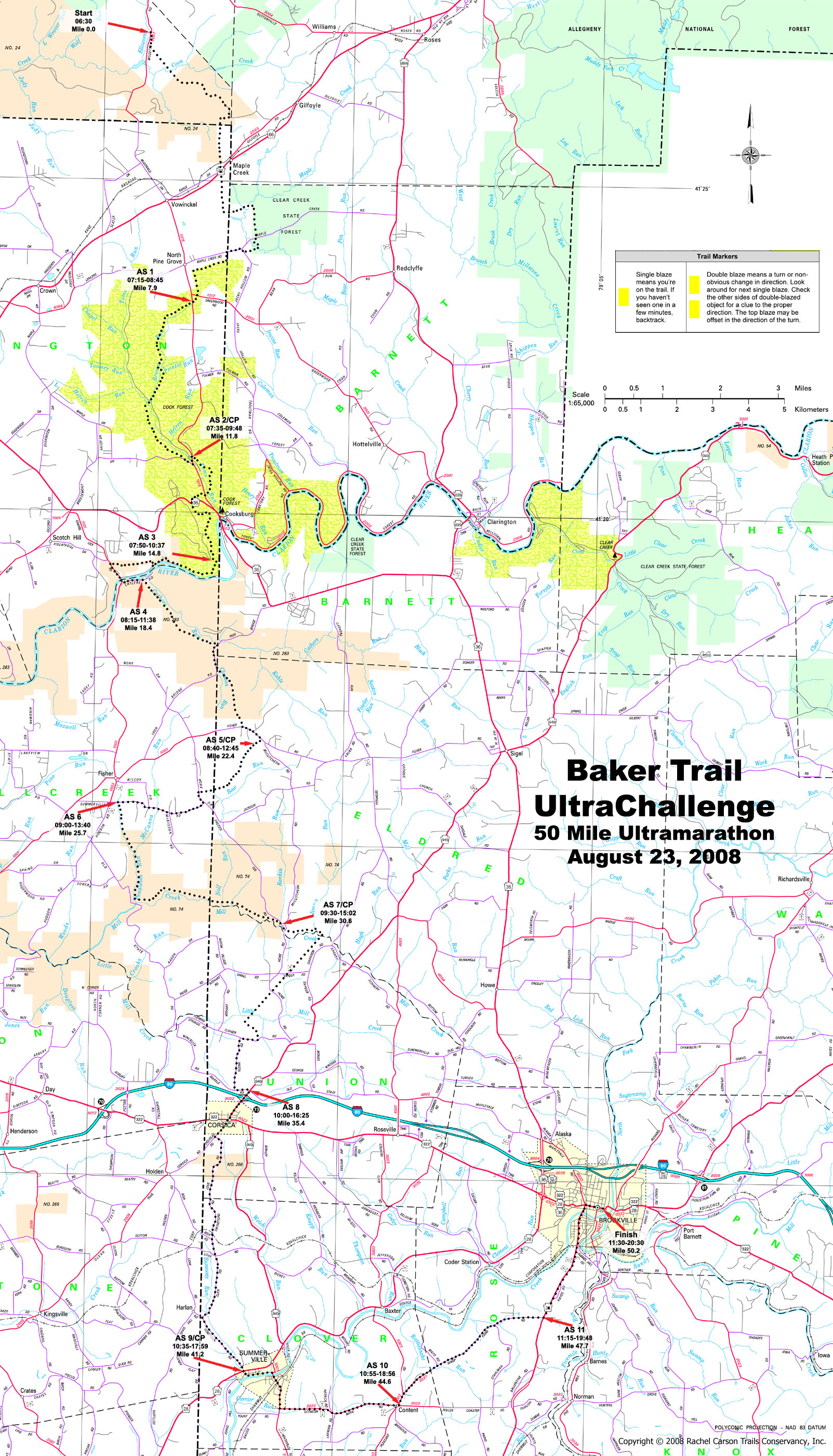
| Aid Station | Cume Miles | AS Delta Miles | Relay Leg Miles | Opening Time | Cutoff Time |
|---|---|---|---|---|---|
| Start: Trailhead (map) | 0.0 | 6:30 AM | AS1: Forest Road(map) | 7.9 | 7.9 | 7:15 AM |
| AS2/CP: Cook Forest (map) | 11.8 | 3.9 | 11.8 | 7:35 AM | 9:48 AM |
| AS3: Fire tower (map) | 14.8 | 3.0 | 7:50 AM | ||
| AS4: Clarion River (map) | 18.4 | 3.6 | 8:15 AM | ||
| AS5/CP: Moose Drive (map) | 22.4 | 4.0 | 10.6 | 8:40 AM | 12:45 PM |
| AS6: Summerville Drive (map) | 25.7 | 3.3 | 9:00 AM | ||
| AS7/CP: Frozen Toe Road (map) | 30.6 | 4.9 | 8.2 | 9:30 AM | 3:02 PM |
| AS8: Route 949 (map) | 35.4 | 4.8 | 10:00 AM | ||
| AS9/CP: Route 28 (map) | 41.2 | 5.8 | 10.6 | 10:35 AM | 5:59 PM |
| AS10: Mt. Pleasant Road (map) | 44.6 | 3.4 | 10:55 AM | ||
| AS11: Route 36 (map) | 47.7 | 3.1 | 11:15 AM | ||
| Finish: YMCA (map) | 50.2 | 2.5 | 9.0 | 11:15 AM | 8:30 PM |
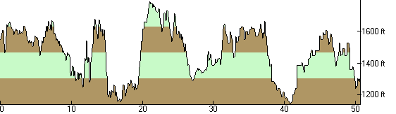
Elevation Profile of the 2008 UltraChallenge
Total Ascending: 4577 ft. Total Descending: 4764 ft.
Finish
All participants will finish back at the Brookville YMCA where food will be provided. Showers are also available for cleanup.
Awards
The awards ceremony will be held at the YMCA at 4:30 PM.
Course
The first relay leg (11.8 miles) is 97% trail, 3% dirt road. The second leg (10.6 miles) is 90% trail, 10% paved or dirt road. The third leg (8.2 miles) is 80% trail, 20% paved or dirt road. The fourth leg (10.6 miles) is 30% trail, 70% paved or dirt road. The final leg (9.0 miles) is 100% paved roads. The trail surface is mostly single-track which can include rocks, roots, sticks, humps, and holes, except in portions of Cook Forest where it's been widened and smoothed.
Along paved roads and at least one critical turn, the course will be marked with Baker Ultra signs in addition to the blazes. In the woods and along forest roads, you'll find the standard yellow blazing.
Be aware that access to the relay exchange point at AS 7 is via dirt road. The road is about 3 miles long, with occasional protruding rocks and some potholes. You won't need four wheel drive, but your vehicle will get dirty (or muddy). Cars with very low suspensions should avoid this area.
Course Map
A map of the course is here (1,293KB JPEG). It is designed to be printed in color (inkjet or laser) on legal size (8.5"x14") paper. Copies of this map will be available at check-in.
Drop Bags
You may leave bags or gear at the YMCA in the morning for pickup and use when you arrive there upon finishing. Also, you may have a bag delivered to any Checkpoint (AS 2, AS 5, AS 7, AS 9), and you may drop off gear, clothing, etc. at any aid station (plastic bags will be available). Everything will be brought back to the YMCA when the aid station closes. Be sure to label everything with your name and ID number.
Rules
Please adhere to these rules or risk disqualification:
- Runners must check-in prior to the race, at each of the checkpoints, and the finish line.
- Runners are not permitted to obtain any outside assistance. If a runner leaves the course for any reason (including getting lost), they must return to the course by their own power at the point they left it.
- Pacers are not permitted for relay runners.
- Pacers are permitted for individual runners beginning at AS9 Route 28 (mile 41.2). Pacers may not carry food, drink, or gear for the runner or provide any other assistance. Pacers must be self-sufficient and not consume any aid station food or drink. Runners are permitted one pacer at a time, and pacers must be at least 18.
- Support crews may meet their runner anywhere along the course, but must not impede traffic. Crews must not park or operate (a) on private property without permission from the property owner, nor (b) in an unsafe manner or location. Runners are responsible for the conduct of their support crew.
Transportation
There is no shuttle service to the Checkpoints! Relay teams must provide their own transportation. If you drop out at an aid station and cannot arrange your own ride, the volunteers will do their best to assist you in securing transportation. However, you will almost certainly be required to wait, perhaps for several hours, for someone to take you. If you drop out between aid stations, you will need to find transportation yourself.
ID Tags
If you drop out and don't make it to the finish, please give your ID tag to a Marshal. If you do not return your tag you will be charged a $5 replacement fee.
Advisories
- Hydrate, hydrate, hydrate. Drink lots of liquid in small amounts at a steady, frequent rate. You should be carrying at least two quarts.
- Water, sport drinks, and snacks will be available at each aid station.
- Wear a hat and use a high-SPF sunblock. You'll be outside all day.
- Watch the weather forecast closely to know what gear to bring; the UltraChallenge will happen rain or shine.
- Stay on the trail!
- Backtrack to find the last trail blaze and reassess your direction if you haven't seen a blaze in a hundred yards or so, as you may have missed a turn.
- Respect private property! Much of the Baker Trail crosses privately owned land and the owners graciously allow us there; do not impose upon any landowner you may encounter.
- Clean up any trash you bring and any you encounter along the way. There are trash receptacles at each checkpoint.
- Stop if you feel sick!
- Check in at each checkpoint. This is how we keep track of you! You must have a time recorded at the start and every checkpoint or your finish time will be disqualified.
Volunteers
We'll need quite a few volunteers to help us stage the UltraChallenge. Please cajole and/or coerce your friends, relatives and co-workers into helping! Email your name and contact info to pabrunner2@yahoo.com!