Overview
 The Harmony Trail is a nearly one-mile long well-maintained and mostly flat, scenic path that is popular with dog walkers, runners, hikers and young bicyclists. It has a surface of crushed limestone similar to most rail-trails like the Montour Trail. It parallels Wexford Run between Route 910 and Richard Road, following the same corridor used by the Harmony interurban trolley from 1908 to 1931. There is no access to the trail from Richard Road at this time.
The Harmony Trail connects with the Rachel Carson Trail which takes you through North Park and across Allegheny County to Harrison Hills Park, approximately 45 miles away. The Harmony Trail will connect to the planned Commodore Perry Regional Trail that is proposed to extend through the townships of Pine, Marshall, Bradford Woods, Cranberry, Jackson and Adams. The Rachel Carson Trails Conservancy is promoting extending the Harmony Trail as a hiking trail to the North Country Trail near McConnells Mill State Park.
Map
Trail Ethics
For the safety and enjoyment of everyone, please observe the following:
- Keep dogs leashed at all times.
- Clean up dog waste & place in the container provided.
- Keep off the trail with motorized vehicles.
- Hunting by permit only; contact Chris.HarmonyTrails.Hunt@gmail.com.
- Carry out your own trash; help by picking up others’ litter.
- Enjoy the trail and be mindful not to trespass on adjacent properties.
In case of an emergency, call 911.
Trail Alerts
- Coyotes have been sighted near the trail, and there's reason to believe they're present most of the time since the habitat is suitable. Be vigilant with small children and pets. (14 February 2024).
Trail Condition
Presently the trail is in good shape. If you notice any problem with trail conditions, signage, or landowners, please email us at info@rachelcarsontrails.org.
Trailhead Directions
- North trailhead (map)
From Pittsburgh, take I79 North to the Wexford exit. Take Route 910 (Wexford Bayne Road) east and travel 1.8 miles. On the right, in the valley directly across from Brennan Road, is an unmarked gravel parking lot which many use to access the trail.
From Route 19 in Wexford turn west onto Route 910. The unmarked gravel lot is on the left in about 0.8 mile.
History
The idea to create a biking/hiking trail along the right of way of the Harmony trolley line goes back a long way. There was an eight mile stretch identified by students in North Allegheny High School's Lifetime Sports club and the North Area Environmental Council (NAEC) in 1974 as a desirable location for a community trail.
In 1992, the NAEC created the Harmony Trails Council (HTC), to concentrate on developing and maintaining a six mile trail between Ingomar and Warrendale. The Allegheny County Greenways Program from the early 1990s focused attention on a potential trail from Pittsburgh to Cranberry which would include parts of the old Harmony Line right of way. In 1994 the Town of McCandless worked on a pilot project for a bike trail on a short section from Potter Park to Pine Creek.
Parcels of land for trail connections were deeded to the HTC by the developers of the Brooktree Corporate Center, led by architect Jack Ross, in 1996. A grant allowed the development of a trail on this land with a crushed limestone surface. Pine Supervisors and the owners of Brooktree Office Park worked together to donate a parcel of land to the HTC so the Harmony Trail could be linked to Brooktree Road and then to North Park.
The mile between Route 910 to Richard Road is fully designated and recorded for the community trail by Pine Township at the north, and by the Town of McCandless at the south.
In 2004 the HTC merged with the group that developed and maintained the Baker Trail and the Rachel Carson Trail, and the new organization was named the Rachel Carson Trails Conservancy.
Since 1992 we have kept the trail clean and had work parties out to repair culverts and clear brush and deadfall. An eagle scout established a narrow trail to connect the gravel parking at 910 with the uphill (official) entry lane. Volunteers have cut brush, trucked in their mowers to improve the edges and have hauled out any trash found.
Harmony Trail Committee/Trail Stewards
These are the volunteers who help manage and maintain the trail:
| Bob Mulshine |
| Eoin Gormley |
| Mike Taylor |
| Charlie Brethauer |
| John Stephen |
| Chris Kelly |
| Deb Elliott |
Trolley History
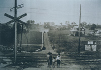
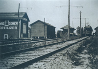
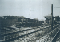
Before there were cars there were trains. Between 1908 and 1931, two companies ran interurban trolleys between Pittsburgh and points north. The Pittsburgh and Butler Street Railway operated the Butler Short Line between Pittsburgh and Butler, and the Pittsburgh, Harmony, Butler & New Castle Railway Company operated the Harmony Short Line from Pittsburgh to Evans City where it split and then continued on to Butler and New Castle. The two companies merged in 1917 and became the Pittsburgh, Mars and Butler Railway.
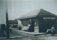
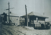
The trolley carried both passengers and freight and was powered by electricity delivered from overhead cables. The cars made frequent stops, although there was a "limited" car that made few stops, and a "party" car for charters. Passengers could board at the Wexford Station, located just north of Route 910, and ride the Harmony Line to Pittsburgh, Evans City and Butler. Connecting tracks also went to Ellwood City, Beaver Falls and New Castle. Travel to Pittsburgh took 52 minutes and cost about 25 cents.
The Harmony Line made it possible to live in the country and work in the city. It also efficiently transported farm products and other freight. During the time it operated about 4 million passengers rode the trolley. When the trolley ceased operations in 1931, the Wexford Station was sold and relocated 1/2 mile to the east near Route 19. Over the years it served as post office, antique store and delicatessen. It now resides at the Pennsylvania Trolley Museum.
Walking along the Harmony Trail today, we can still appreciate the quiet, rural character of the Wexford Run valley and imagine a trolley ride here many years ago.
The rise of the automobile, in particular the bus, and the Great Depression conspired against the trolley. It ceased operating in 1931, and the land was sold and put to other uses. The section that followed Girty's Run out of Millvale was acquired by the county and became Babcock Boulevard.
Locally, the trolley ran along a wooded valley that parallels today's Route 19. The rail bed followed the only level right of way available through the North Hills' otherwise steep terrain. Today, more than 85 years after service was abandoned, its tracks are gone. Much of its old alignment has given way to pavement, housing developments, and other forms of progress. Between Ingomar and Warrendale, however, a scenic stretch of the old Harmony right of way remains largely intact. As with many rails-to-trails projects throughout the country, the wide, flat corridor is ideal for a trail, and the Harmony Trail occupies a short section of it.
The Pittsburgh City Paper (dead, now links to archive.org) noted, somewhat wryly, that plans for a similar regional transport system are being promoted today, yet it existed over 75 years ago, and was accomplished without magnetic levitation.
More historical details can be found on this rail enthusiast's site (dead, now links to archive.org), at the Pennsylvania Trolley Museum, or Wikipedia. Photographs from the trolley era can be seen on the University of Pittsburgh's Historic Pittsburgh site. The Northland Public Library also has a flat file with articles and pamphlets about the trolley line and the efforts to develop hiking & biking trails in the area of the old line. A short video of the trolley being used can found here.