Participant Information
Check-In
The Challenge will take place rain or shine. Upon arrival at the trailhead in Harrison Hills Park, all participants must first check in at the Bobwhite Shelter. This is so we can record your participation and you can pick up your ID tag and maps. Please pin the tag on your right side at waist level so it can be scanned at each Checkpoint. Memorize the number on the tag as it will be called out at each checkpoint when it is scanned. You are responsible for ensuring your tag is properly scanned! Registration opens at 5:00 AM. Note that the Challenge does not start at the actual eastern trailhead, due to parking limitations there.
Starting
To reduce trail congestion, the Challenge has no group start time. You may start when ready, as early as 5:15 AM if there is sufficient light, and as late as 6:30 AM. Make sure you stop at the trailhead and let the Trail Marshal there scan your tag so we know you've left and have an accurate start time. Registration closes at 6:30 AM. Checkpoints
There are four checkpoints on the Challenge, each with water, snacks, basic first aid, cell phones and radio communications. You must reach each checkpoint by the indicated cutoff time or you will be required to drop out.
| Checkpoint | Miles Out | Opening Time | Cutoff Time |
|---|---|---|---|
| Harrison Hills Park Registration (map) | 0.0 | 5:00 AM | 6:30 AM |
| Bull Creek Road Checkpoint 1 (map) | 6.9 | 6:00 AM | 9:30 AM |
| Agan Park Checkpoint 2 (map) | 14.8 | 7:45 AM | 12:45 PM |
| Log Cabin Road Checkpoint 3 (map) | 20.1 | 9:00 AM | 3:30 PM |
| Shaffer Road Checkpoint 4 (map) | 26.6 | 10:30 AM | 6:30 PM |
| North Park Finish/Cookout (map) | 34.6 | 12:00 PM | 8:54 PM |
Course Alert
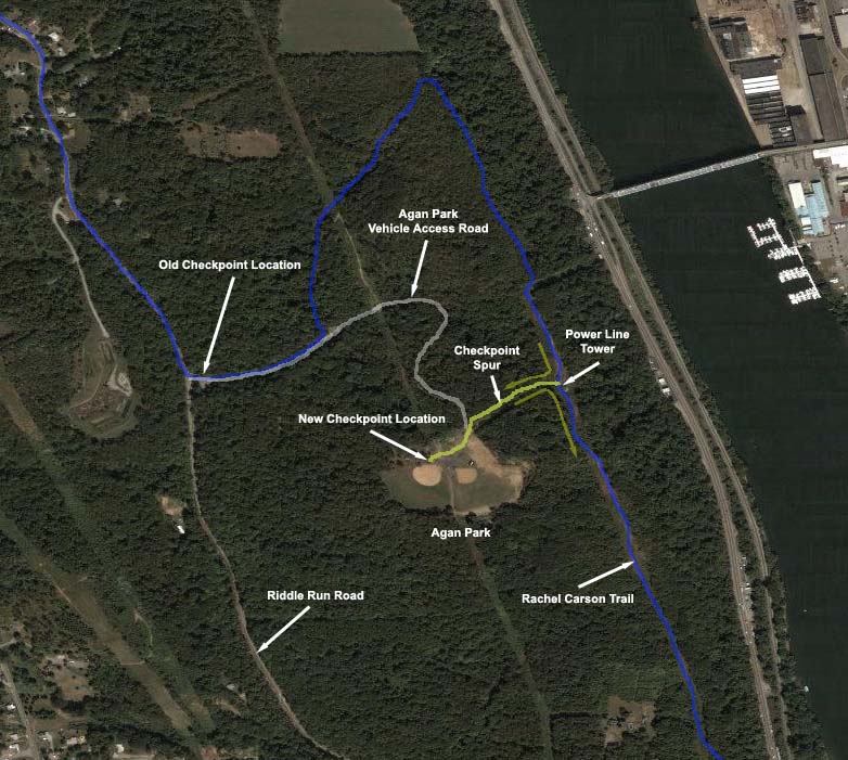
Beginning last year, Agan Park Checkpoint 2 moved from the park entrance to within the park. This provides a shelter with picnic tables and port-a-johns. Challenge participants will take a spur trail from the Rachel Carson Trail to get to the checkpoint and return to the Trail via the same route. This spur will not be blazed as it is not part of the Trail, but a sign will be posted at its junction with the Trail. The length of this spur is about 1,000 feet each way. An image showing this change is here. The indicated power line tower is the only steel tower along the bluffs.
Toilets
This year there will be portable toilets at every checkpoint. Please try to utilize them instead of the woods.
Transportation
There is no official shuttle service to the Checkpoints! If you drop out at a Checkpoint and cannot arrange your own ride, the Trail Marshals will do their best to assist you in securing transportation. However, this is not guaranteed and you will almost certainly be required to wait, perhaps for several hours, for someone to take you. If you drop out between Checkpoints, you will need to find transportation yourself or wait by the trail for the Trail Sweeps to come through and they will assist you as best they can.
ID Tags
You must turn in your ID tag in order to receive your t-shirt. If you drop out and don't make it to the finish, please give the tag to the supervisor of the closest Checkpoint. If you do not return your tag you will be charged a $5 replacement fee.
T-Shirts
The t-shirts are distributed at the finish in North Park. You will be required to turn in your ID tag in order to receive your shirt. If you drop out, be sure to stop by the finish and collect yours. And while you're there, enjoy the cookout!
Parking
The Challenge is a point-to-point course, not a loop. When you finish you will be 34 miles away from where you started. You have two parking options:
- Park at North Park next to the Beaver Shelter (the Challenge endpoint) and ride the predawn trailhead shuttle to Harrison Hills Park. The benefit of this option is you will be at your car when you finish the Challenge. The drawback is you will need to get up earlier to board the bus.
- Park at Harrison Hills Park (the Challenge trailhead), do the Challenge, then wait for the shuttle to take you back to Harrison Hills Park from North Park. The benefit of this option is you don't need to get up quite as early. The drawback is you will need to wait for the shuttle (perhaps 90 minutes or more) after you finish the Challenge (also note that the shuttle starts running at 4 PM). However, there will be a cookout at the Beaver Shelter for you to partake while waiting.
You cannot park overnight on Friday at either the start or finish. Both locations are in county parks which close at night. No vehicles are permitted to remain in the park overnight, with or without occupants.
Trailhead Shuttle Itinerary
The trailhead shuttle bus will arrive at the Beaver Shelter in North Park at 4:20 AM, load for 10 minutes, then depart. The shuttle will arrive in Harrison Hills Park at the Bobwhite Shelter in time for you to check in and be on the trail at sunrise, 5:54 AM. Please be on time for the shuttle, it cannot wait for you!
Directions
- To Harrison Hills Park Bobwhite Shelter: Take Route 28 to exit 16, turn east (right if exiting northbound) at the end of the ramp, then right again at the T-intersection with Freeport Road. The park is about one mile down on the left. Take the left fork of the Park entrance road and follow it 1/2 mile to the shelter parking lot on the right at the Bluejay sign. Map
- To North Park Beaver Shelter: From Pittsburgh, take I279 North to the McKnight Road exit and travel 6.4 miles north. Take the North Park/Ingomar Rd. exit east and turn left at the third traffic light onto Babcock Blvd. The parking lot is on the left at the next intersection with Pearce Mill Road (aka Pierce Mill Road), and the Beaver Shelter is at the far end of the lot. Map
- To Checkpoint 1: Take Route 28 to Exit #14 (Tarentum). Turn north (left if exiting northbound) on Bull Creek Road for a very short distance, turn right on Ridge Road, then immediately turn into the parking area on the right. Map
- To Checkpoint 2: Take Route 28 to Exit #12A (Pittsburgh Mills). At the end of the ramp, turn away from the mall on the main entrance road (follow signs for Creighton), then turn left onto Tawney Run Road. After about 1/2 mile turn right on Riddle Run Road. Travel another mile and turn left into the entrance to Agan Park. Continue up the 1/2 mile park access road to the ball fields (note this is a rough, dirt road -- consider parking at the entrance and walking up). Map
- To Checkpoint 3: Take Route 28 to Exit #12. Turn right at the end of the ramp, then right at the stop sign onto Little Deer Creek Road (aka Russellton Road). Travel about 1.5 miles and turn right on Log Cabin Road. Park about 100 yards ahead on the right. Map
- To Checkpoint 4: Follow Route 910 along the Yellow Belt to 1/2 mile west of the Saxonburg Blvd. intersection and turn onto Cedar Run Rd. (at the Sunflower Valley Market). Travel about 1 mile (stay left onto Shaffer Road at fork) to a wide area in the road where you may park on the left. Map
Advisories
- Hydrate, hydrate, hydrate. Drink lots of liquid in small amounts at a steady, frequent rate. You should be carrying at least two quarts.
- Water and snacks will be available at each checkpoint, every 7-8 miles.
- Wear a hat and use a high-SPF sunblock. You'll be outside all day.
- Watch the weather forecast closely to know what gear to bring; the Challenge will happen rain or shine.
- Stay on the trail. Shortcuts may not be fair to other participants and can upset landowners.
- Backtrack to find the last trail blaze and reassess your direction if you haven't seen a blaze in a hundred yards or so, as you may have missed a turn.
- Resist forging ahead or spending time trying to "hook up" with the trail if you lose it; this rarely works to your benefit.
- Respect private property! Much of the Rachel Carson Trail crosses privately owned land and the owners graciously allow us there; do not impose upon any landowner you may encounter.
- Clean up any trash you bring and any you encounter along the way. There are trash receptacles at each checkpoint.
- Stop if you feel sick! You won't be alone, plenty of participants don't finish.
- Check in at each checkpoint. This is how we keep track of you! You must have a time recorded at every checkpoint or your finish time will be disqualified.
- There is a Sheetz (a regional convenience store) on Freeport Road in Creighton, less than 200 feet off the trail at mile 11; consider carrying some cash for sudden cravings, medicine, or other necessities.
Volunteers
We need quite a few volunteers to help us stage the Challenge. Please cajole and/or coerce your friends, relatives and co-workers into helping! Check out the Volunteers page for details.